1. System Requirements and Application Analysis
With the rapid development of urbanization in China, modern public transportation systems such as subways, light rails, and high-speed rail have become essential components of city mobility. However, challenges remain, including high capital investment, limited funding sources, and inefficient vehicle management after deployment. Traditional vehicle monitoring systems often rely on single-chip microcontrollers for data collection, SMS for communication, and MapInfo as a GIS platform. These systems suffer from poor scalability due to the lack of an operating system, limited bandwidth that restricts multimedia transmission, and high costs that hinder widespread adoption across different transport sectors. To address these issues, this paper introduces a vehicle monitoring and management system based on the domestic Beidou navigation satellite system. The system uses an ARM9 S3C2410 processor as the main control unit, integrating GPRS and internet connectivity for real-time data transmission. SMS is used as a backup communication channel to ensure reliability. The system also supports image and voice data transfer, enhancing its functionality. A well-known Chinese mapping provider, 51ditu, is utilized as the GIS platform due to its open APIs and high accuracy, making it ideal for this application. This system can be applied in various fields such as urban public transport, taxis, buses, logistics, and hazardous material transport. The compact onboard terminal allows flexible configuration of monitoring modules based on specific needs. The central monitoring center can track vehicles in real time, issue commands, and receive feedback, significantly improving operational efficiency and safety. By leveraging the Beidou system, the solution reduces costs, enhances security, and improves overall vehicle management capabilities, offering great value for logistics and public transport sectors.2. Working Principle of the System
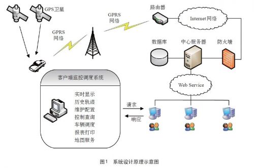
The system operates by receiving satellite data from the Beidou navigation terminal installed in the vehicle. This data is then transmitted via GPRS and the internet to a central server, where it is parsed and stored in a database. The monitoring center accesses the database through web services, and the GIS platform displays the collected information. It can also send alerts and control commands back to the vehicle, enabling efficient monitoring and management. The system design is illustrated in Figure 1.
3. System Architecture Design
The vehicle monitoring and management system comprises three main components: the onboard unit (Beidou navigation terminal), the monitoring center (client), and the central server (server software and database). Each component plays a critical role in ensuring seamless communication and effective vehicle tracking.3.1 Onboard Unit
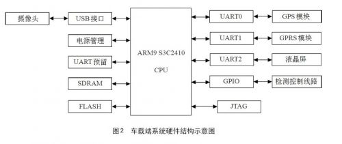
The onboard terminal is built around an ARM9 embedded system, equipped with a GPRS module (Huawei GTM900C), a Beidou navigation module (SiRFStarIII), an LCD display, and a keyboard. It can connect to external devices like cameras and mobile phones for video and voice transmission. Additionally, it interfaces with the vehicle's sensors via GPIO ports to collect various operational data. The system architecture is shown in Figure 2.
The GPRS module communicates with the ARM processor and connects to the mobile network to transmit data to the monitoring center. The Beidou module sends location data via a serial interface to the main controller for processing. Flash memory stores the embedded Linux OS and application programs, while the LCD displays system status and user instructions. The detection circuit collects sensor data and sends it to the CPU for real-time monitoring and analysis.
 [1] [2]

Smb Connector,Smb Rf Coaxial Connector,Smb Coaxial Cable Connector,Smb Coaxial Connector
Changzhou Kingsun New Energy Technology Co., Ltd. , https://www.aioconn.com