At present, China's society is in a period of transition. The various social contradictions caused by the widening gap between the rich and the poor and the increase of relative poverty have aggravated the frequent occurrence of various mass incidents, and the social security situation is grim. In particular, the recent frequent incidents of vicious violence on campus have raised concerns about the worsening social security situation. As the main force for maintaining public security, the police in Tongxiang, Zhejiang Province have launched a number of measures such as “street patrol†and “big visit†to maintain the social security situation, and put the frontline police force into the daily patrols of the street and the community. In order to improve the maneuverability of the police and achieve flat command, it has the dual effect of improving the detection rate of the current case and reducing the rate of filing. However, how to monitor, guide and evaluate the effectiveness of these measures has been lack of effective quantitative analysis, which has affected the correct assessment of these measures.
This article refers to the address: http://
The GPS patrol management system uses the GPS positioning and walkie-talkie system to realize quantitative management and real-time command of the entire patrol route and personnel. The geographic coordinates, time, speed and other data sent by the GPS terminal are transmitted back to the command center through the police wireless channel. Grid patrol management is performed on the GIS electronic map, and the location and related information of the patrol personnel are displayed on the map. Regardless of the complexity of the community, the command center can determine the geographical location of the patrols as quickly as possible, so that it is convenient to mobilize the police to rush to the scene, thus more effectively maintaining law and order and fighting crime. The system can also query, analyze and judge cases that occur within a certain period of time to determine the best patrol route, and on this basis, supervise police and daily patrol work.
System Components
The system consists of three parts: GPS data terminal, wireless transmission system and positioning and management software. See system structure diagram 1, each part has the following functions.
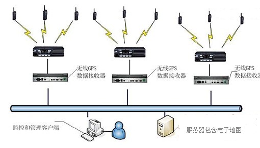
Figure 1 Structure of police GPS patrol management system
· GPS data terminal: The high-sensitivity GPS signal receiver is built into the shoulder microphone of the walkie-talkie or walkie-talkie, and the GPS data is transmitted through the police wireless intercom system. The carrier (mobile, China Unicom and Telecom) wireless channel can also be used as the reporting channel, and the battery can be independently powered;
· Wireless transmission system: GPS data can be reported by the police wireless intercom channel, or the public carrier (mobile, China Unicom and telecommunications) wireless channel can be used as the reporting channel;
· Positioning and management software: It consists of data receiving server, database server, application server, client software and other modules, and supports ARCGIS and MAPINFO electronic maps.
The wireless GPS module walkie-talkie periodically collects GPS data from the satellite positioning system and transmits it to the central station through the wireless system, and then outputs the GPS data through the receiver. The GPS data is transmitted to the digital patrol and intelligent positioning service system through the network, and the uploaded information can be The same channel as the voice can also be transmitted through the independent traffic channel. In addition, GPS data can also be reported via the carrier (Mobile, China Unicom and Telecom) wireless channels. The positioning and management software has complete equipment and user management functions, saves the collected information to the database through the network, and displays the real-time positioning information of all users and its current status in combination with the electronic map system. Any authorized online user can monitor the distribution and real-time status of the police force in the network in real time. It can effectively guide and supervise the daily patrol work of the police officers. In the event of an emergency, the nearest rapid deployment can be implemented to achieve rapid dispatch and scientific command.
Main application of the system
According to the specific situation of public security work, the system can be used for the following specific applications.
1. Establish a police command center
Based on the dispatching platform of the bureau command center, through the cooperation with the 110 wired alarm system, network alarm and geographic information system, the public security system dispatching command center is formed. The command center can grasp the position information of the patrol vehicles and personnel at any time. After receiving the alarm, it promptly displays the location of the alarm target on the electronic map, and dispatches the nearest patrol vehicle or other police force to handle the alarm through the intercom system. The command center can also analyze and judge various police situations through software, and conduct early warning information release, patrol route setting and supervision.
2. Positioning, calling and command between the command center and the patrol vehicle
Install a GPS positioning module and a car radio on the patrol car, patrol according to the designated line. After receiving the alarm, the command center assigns and mobilizes the patrol vehicle according to the alarm position displayed by the GIS geographic information system and the location of the adjacent patrol vehicle provided by the GPS system. Quickly arrive at the scene, control the situation in time and take precautionary measures.
3. Positioning, calling and command between the command center and the patrol personnel
With the GPS positioning module on the handheld walkie-talkie, the individual positioning monitoring can be realized. The command center can know the current position of the patrol personnel in time through the positioning points that are regularly reported. The patrol personnel can also touch the walkie-talkie when there is an emergency situation requiring police support. The PTT button asks for help and reports the location point, so that the command center can perform effective full-time monitoring of the patrol personnel, which helps to improve the ability to control and handle emergencies.
The system can also supervise the route and patrol time of patrol personnel, and conduct online management of patrol personnel in accordance with the requirements of grid patrols, further supervise patrol personnel to perform their duties and do patrol work.
Main function of the system
1, positioning and scheduling
· Positioning and real-time trajectory function: The system automatically locates on the electronic map based on the GPS data reported periodically, and forms a corresponding trajectory. The trajectory can be set according to walking patrol, police car patrol, and assisted car patrol.
· Police dispatch: Click the dispatch button and select the incident point on the electronic map. The system will search for police information such as patrol personnel, vehicles and police rooms within a certain range to achieve the nearest dispatch;
· Automatic tracking: The system can be set to automatically track a patrol person and vehicle;
· Active reporting: The patrol personnel press the PTT button on the intercom to automatically report the location information to the system;
· Historical track playback: The system can play back the past patrol situation, select the time range, area range and playback speed, and realize the functions of fast forward, slow forward, point-by-point playback similar to video playback.
2. Patrol management
This function is mainly developed for the actual needs of police work, covering all aspects of digital patrol research, warning, inspection, supervision, etc. The main functions are as follows:
· Patrol line setting: through the analysis of high-incidence cases and hotspots, set up corresponding patrol lines, and release them through the management system every week to guide patrol personnel to patrol on time according to the line;
· Patrol personnel management: set up patrol personnel information and set up their patrol lines;
· Patrol inspection: By comparing the preset line with the actual trajectory, determine whether the patrol personnel are patrolling in place, especially if some must-have points have been patrolled on time;
· Patrol area setting and cross-border alarm: Set the corresponding patrol area. If the patrol personnel leave the patrol area within the specified patrol time, the system will automatically alarm and record the event;
· Video surveillance: Display the street camera video in conjunction with the map, and synchronize the query with the patrol track to view the patrol time screen.
3, map operation
· Hawkeye function. The system can perform fast map movement through the eagle eye;
· Geographic information suitable for police use. The map has various police information such as branch offices, police stations, patrol areas, communities, police offices, and high-issue and easy-to-issue points;
· Complete map operations. The map can be enlarged, reduced, roamed, layered, etc., which can be marked and positioned on the map; relevant geographic information can be inquired, such as roads, residential areas, intersections, important sections, special industry units, etc. Distance between two or more points and area of ​​the area.
4, background and log management, to achieve the establishment and management of public security organizations at all levels, complete detailed log records and query functions.
· Information settings. Unified management and setting of police stations, patrol areas and patrol personnel; unified management and setting of system users;
· Logging. All important operations, such as login, logout, control, etc., have operation records; provide multiple logs (operation log, login log, exception log, alarm log, etc.) for users to query;
· Clock synchronization. Provides a server-based clock synchronization system, or dual-clock synchronization with GPS to ensure time synchronization of all information;
· Permission settings. The permissions and priorities can be set uniformly by group. User rights are mainly reflected in the following two aspects:
User function permission: Each user can have different function rights. For example, the general user can only query the patrol track, but does not have the functions of background management. The function permission setting can better reflect the management requirements of the public security department and prevent the level of operation; User zone permissions: Under normal circumstances, users can only see information about jurisdictions. For example, a police station staff can only monitor the trajectory of the police station patrol personnel.
5, the main function demonstration
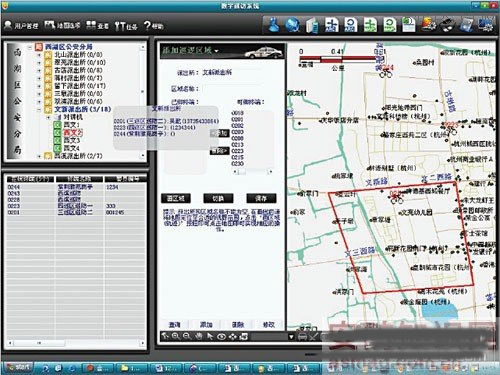
Figure 2 Police GPS patrol management system interface diagram
The main interface is divided into four areas:
· Tree list area (upper left area): This area displays the information of the branch office, police station and tour area. If you click the node on the tree, the map automatically locates the corresponding position;
· Map area (upper right area): This area is used for GIS map operations and has a complete map operation function;
· Terminal information (lower left area): This area lists all online GPS terminal information, including: terminal number, terminal name, police officer number, police officer name, contact information, patrol mode, terminal online information, and can be combined and sorted;
· Information display area (lower right area): The information display window is mainly used to display some key system operation information, such as system startup and terminal information modification.
According to the interface, the main functions are demonstrated as follows.
1. Track playback - query the patrol information of the patrol personnel through time, display the track map within a certain time period on the map, and realize functions such as fast forward, slow forward, and point-by-point playback similar to video playback.
2, police force schedule - by clicking on a certain incident point, to obtain the police situation in the surrounding area of ​​patrol personnel, patrol vehicles and police rooms, so as to achieve online scheduling, the size of the scheduling area can be set.
3. Police officer information to conduct online patrol trajectory configuration - set the patrol line and the patrol line of the patrol personnel for a period of time.
4. Patrol area setting and cross-section alarm - Set the patrol area. Correspondingly, if the patrol personnel exceeds the preset area, the system will automatically alarm.
5. Patrol supervision
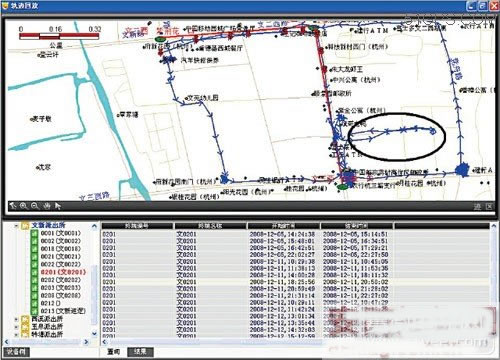
Figure 3 patrol supervision track map
In Figure 3, the red line is the preset trajectory, and the blue line is the actual trajectory. It can be seen that although the patrol personnel showed a short deviation from the route during the patrol process (the part shown in the black circle in the figure), it basically follows the preset. It is required to patrol the necessary points and routes, see Figure 3.
6, background management - unified management and settings for the police station, patrol area, equipment, users, a total of 9 functional modules.
· Modify personal information: modify the basic information of the login user, such as address, phone number and other information;
· User Management: View, add, modify or delete user information;
· Role management: view, add, modify or delete role information, generally configured by group;
· Rights Management: Configure the permissions that the role has;
· Police station management: view, add, modify or delete police station information;
· Device (interphone) management: view, add, modify or delete device information;
· Public security sub-bureau configuration: view, add, modify or delete public security sub-bureau information;
· Community (tour area) configuration: view, add, modify or delete information of each community or tour area;
· Password modification: modify the login user's personal password.
System Features:
· After installing the GPS positioning module on the regular walkie-talkie, the module is suitable for the existing walkie-talkies of various brands, fully protecting the original investment, and is suitable for units that already have a large number of walkie-talkies;
· Realize GPS positioning on the distribution equipment such as walkie-talkie, no need to add special equipment, suitable for the current police officer's duty mode;
· The communication protocol uses encryption and error correction mechanisms, and the encryption and error correction methods are suitable for public security applications;
· Complete background management system, which can be set up according to the organization of the public security system;
· It has a complete patrol management system covering all aspects of the existing public security system, such as judging, arranging, monitoring, dispatching, and supervising;
· Features such as effective and invalid trajectory differentiation, police personnel analysis, trajectory point-by-point analysis, patrol mode setting, etc.
· The software adopts C/S and B/S compatibility mode;
· Different colors of each walkie-talkie can be distinguished by color, such as online, return to the return point, in the patrol, rest, etc., and the return point can be directly marked by the system;
· Automatically count the dwell time at a certain point during track playback;
· When the track is played back, it has the functions of fast forward, fast reverse, etc. similar to video playback, which is convenient for retrieval and analysis;
· It is possible to compare the necessary and actual visit routes directly on the same interface for easy supervision;
· The tour area can be set, and the relevant personnel will leave the specified area when they visit;
· Click on a incident to automatically search for nearby police forces.
Conclusion
The operation of the system can effectively manage and supervise all patrolling police officers who perform tasks on the street, realizing real-time command and quickly arresting criminals when they are issued. The system also enables the feasibility of quantitative analysis in all aspects of patrol duty, thus providing first-hand information for further patrol work.
Introduction to LED peripheral products: all Led Display screens are composed of peripheral products. The surrounding products are mainly divided into these categories.
I. video processor, which is often used in engineering and leasing. Image zooming.
The display mode of Led Display Screen is point-to-point, which determines that the LED display screen can only display pictures with the same physical resolution size as itself. LED video processor can zoom the image, output the picture in any size, and map the whole desktop to the Led Screen.
2. Signal conversion and switching
Video processing equipment can complete the format conversion among many signals. Another important function of the video processor is to manage all kinds of signals when there are multiple access signals, and to switch between them flexibly.

3. Image quality improvement
Because the pixel spacing of LED display is much larger than that of other flat-panel display media, there are strict requirements for image processing technology, especially image enhancement technology. High quality LED video processor can use advanced algorithms to modify the signal with poor image quality, perform a series of processing, such as de interlacing, edge sharpening, motion compensation, etc., to enhance the details of the image and improve the image quality.
4. Large screen splicing
At present, the point spacing of LED screen is becoming smaller and smaller, and the overall dimension is becoming larger and larger, which makes the physical resolution of LED screen become very large. LED video processor with splicing function can drive large-resolution screen, which is a very cost-effective driving mode.
5. Multi screen processing
In many special scenes, a display screen needs to display multiple images with the same or different signals. The video processor with multi image processing function can flexibly meet such display requirements.
Due to the influence of regional weather and other factors, the outdoor display screen requires the video processor to have more excellent image quality improvement ability and advanced image scaling algorithm to ensure the sharpness and gray level of the image to the greatest extent after the video image is scaled. In addition, the video processor is also required to have a wealth of image adjustment options and effects to process the image brightness, contrast and gray level, so as to ensure the soft and clear screen output.
II. Air plug connector. Power and data are transmitted between boxes through air plug connector. The air plug is mainly divided into male head and female head. It is divided into indoor and outdoor according to the use scenario. His use makes the connection fast and safe.
3. Wire, the wire is mainly divided into 1 and 5V power lines, the wire connecting the power supply to the card, 2 and 220V power lines, the network cable connecting the power supply and the power supply, 3, the signal network cable, the network cable connecting the receiving card and the receiving card, 4, the cable arrangement, the cable arrangement between the module and the module and between the receiving card and the module. 4. Card wire, wire connecting receiving card and power supply
IV. receiving card is mainly used to receive data processing data and set screen parameters according to screen.
V. main card: the main card is divided into synchronous sending card and asynchronous card. The synchronous sending card is the synchronous display of the computer or other signal sources. The asynchronous sending card is to preset the content, send and store. Then the signal is off the external link.
Vi. power supply, which is mainly used to provide transformer power for screen body, also called transformer.
7. Box structure, mainly including die-casting aluminum box and iron box according to material classification, simple box and waterproof box according to use.
Peripheral products are selected according to customers' requirements, with various brands.
Led Screen Guard,Led Screen Protector,Lcd Led Wall Mount,Led Display Accessories
Shenzhen Vision Display Technology Co,.LTD , https://www.ledvdi.com